Skip to main navigation Skip to main content
Map of Old Fort Earthworks for the 1800s

Old Fort Earthworks

Site ID: 15Gp1

Earthen enclosure
Greenup
Kentucky Archaeological Survey
Unless specified, we cannot provide site location information.

Summary

​​​​​​​​​​​​​Old Fort Earthworks is the westernmost segment of the expansive Middle Woodland earthworks and mound complex known as the Portsmouth Group.  It sits on a terrace overlooking the Ohio River floodplain. 

The square earthen enclosure surrounds 13.5 acres. It's north and south walls measure 825 feet long, and its east and west walls measure 822 feet long. The corners - not the walls - are oriented to the cardinal directions. Thus, the walls are set at a 45° angle to the cardinal directions. 

Other elements of the Old Fort Earthworks are pairs of long, parallel, linear, low-lying embankment "arms." They extend from the east and west walls, respectively. The width of the "arms" at the base varies from 20 to 36 feet, and their height varies from 1.5 to 3.5 feet.​

Northwest corner of the enclosure in 1938.

Findings

​An impressive feature on the landscape, Old Fort Earthworks was first mentioned by Hanson and Company in 1774. The men were surveying land at the mouth of the Scioto River for Patrick Henry and noted its presence in their journal. They incorrectly assumed that the ancient enclosure was the remains of a 1750s stone trading house. 

Throughout the 1800s, antiquarians mapped and described the site. The only systematic excavation of Old Fort Earthworks took place during the Great Depression. WPA workers in 1938 topographically mapped the enclosure and excavated trenches and test units. Some were placed inside the enclosure, while others cross-sectioned select enclosure walls and one of the "arms."
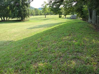
Same view of the northwest corner of the enclosure - 59 years later in 2007.

Stratigraphy in the East Wall trench profile revealed how Native engineers built the walls. The old humus layer, 6 to 8 inches thick, remained below the wall. They covered that layer with a 2-foot-thick mixture of soil and humus from the immediately surrounding area. Native builders then formed the wall core by mounding-up thousands of basketloads of sand, gravel, loam, or clay - taken from various sources - to a height of 6 feet. They immediately placed a layer of yellow-brown clay over the core to dress it off, forming a smooth slope. 

Trench through the enclosure's west wall:  Note the dark line of soil - the original ground surface.

What's Cool?

​​Ancient Engineering and Land Modification​

Native groups built Old Fort Earthworks to reflect their symbolic and sacred/religious values, and according to clearly defined plans for enclosure dimensions and orientation. 

These ancient engineers overcame the particular shortcomings of this spot by filling-in ravines and cutting slopes.  They also removed the remains of previous Native  occupations and used those deposits in wall construction. In other places, they covered the slope with fill to ensure that the wall would remain relatively level. 

The enclosure builders, and all subsequent Native groups, kept the area within the walls clean and free of any cultural materials.  

Native engineers built the wall (the core is different-colored soils) over the original sloping ground (dark soil line).

Related Materials


Keep the Search Alive!

Learn more about the ROBOT INSERT TIME PERIOD HERE.